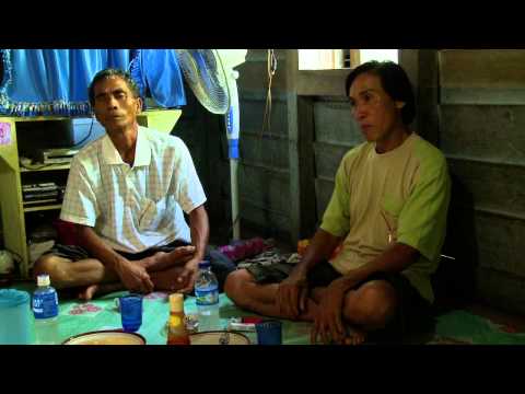
NEW VIDEO: 'Mapping our Future' for survival of local communities in Indonesia
Between 2010 and 2013, Both ENDS, within an alliance of Indonesian and Dutch organisations and universities, conducted a pilot project to improve the spatial planning in the district of Sanggau in West-Kalimantan, on the island of Borneo, Indonesia, to help local communities with the recognition of their land rights. We can show you a beautiful documentary about one of the villages in this district, Terusan.
Mapping for the future
Terusan is a village completely surrounded by oil palm, the villagers however produce mainly rice and rubber on their ancestral lands. When an oil palm company offers Terusan to convert their village land to an oil palm plantation, the villagers suddenly face a difficult choice. Do they choose for the prosperity that is promised? Or does this make the future of their children too insecure? They decide to map their property first.
An exact map empowers villagers
In Indonesia, official spatial maps are large-scale sketched maps, highly inaccurate regarding village boundaries. The official maps of a district often don’t show the land that has been used by the villagers for many generations. This causes local governments to allocate land for oil palm plantations that is already in use by local famers, often leading to conflicts and violence.
Because the land rights of the local communities are not officially recognised, negotiations between the companies and communities often take place on unequal terms, as the communities are unaware of the extent of their customary lands and the rights they have. Also, what many communities don’t know is that when a company’s lease contract over a piece of land ends, it will be returned to the state and not to the local community. The land will never be theirs again.
To claim their land rights, the villagers of Terusan decide to start mapping their lands. When the local governments include their mappings in its official district maps, future investors are forced to first consult the local community about their plans. If the official district maps show that the land is already in use by the villagers, they have to give their permission to the investor for using the land, such as for the exploitation of palm oil plantations.
Decision for future generations
It is therefore very important that local communities are involved in the official mapping process of the districts by local governments. In this way, their land rights are recognized and the villagers are empowered to decide themselves about the future of their lands: will they strike a deal with the palm oil company or will they keep the lands for their own use, and that of future generations?
Take time to watch the beautiful documentary, directed and produced by Peter de Koning.

Read more about this subject
-
Letter / 14 July 2026
Statement on CAO Cambodia Microfinance Case
The independent complaints mechanism of the International Finance Corporation (IFC) and the World Bank Group found that the IFC violated its own Environmental and Social Sustainability Framework by investing in six banks providing microfinance in Cambodia.
-
 News / 6 July 2026
Strengthening Women's Land Rights Across the Rio Conventions
From 29 June – 2 July 2026, Tamara Mohr, GAGGA coordinator at Both ENDS participated in the 4th convening of the Women's Land Rights Initiative (WLRI) in Nairobi, Kenya.Hosted by the Robert Bosch Stiftung, TMG Research and the Huairou Commission, the event brought together grassroots organisations, (inter)national NGOs, government institutions and donors from around the world.
-
Publication / 3 July 2026
-
 Dossier /
Communities Regreen the Sahel
In various countries in the Sahel, vast tracts of land have been restored by the local population by nurturing what spontaneously springs from the soil and protecting the sprouts from cattle and hazards.
-
 Dossier /
Gas in Mozambique
In 2011 one of the world’s largest gas reserves was found in the coastal province of Cabo Delgado, in the north of Mozambique. A total of 35 billion dollars has been invested to extract the gas. Dozens of multinationals and financiers are involved in these rapid developments. It is very difficult for the people living in Cabo Delgado to exert influence on the plans and activities, while they experience the negative consequences. With the arrival of these companies, they are losing their land.
-
 Dossier /
Finance for agroecology
The lion's share of public budgets for climate, agriculture and development still goes to conventional agroindustrial projects that contribute to the current climate, food and biodiversity crises. Both ENDS and our partners are calling for a transition to agroecological practices that are people- and environment-friendly.
-
Publication / 18 June 2026
-
Publication / 12 May 2026
-
 Press release / 12 May 2026
UN report warns of a growing sand crisis - The Dutch dredging sector plays a key role in global sand extraction
GENEVA/UTRECHT, 12 May 2026 – A new report by the United Nations Environment Programme (UNEP), Sand and Sustainability: An Essential Resource for Nature and Development, warns that global demand for sand is exceeding ecological limits. Large-scale extraction of sand from marine and coastal ecosystems is leading to biodiversity loss, damage to coastal communities and increasing risks in an era of climate change. Dutch dredging companies play a prominent role in this as global market leaders in large-scale sand extraction and land reclamation. “Our analyses show that the dredging sector operates globally within a system in which ecological damage and the consequences for coastal communities are systematically underestimated, whilst transparency and effective oversight are often lacking,” says the Dutch environmental and human rights organisation Both ENDS, which contributed to the report.
-
 Dossier /
Rights for People, Rules for Corporations – Stop ISDS!
Indigenous communities in Paraguay saw their attempts to regain their ancestral lands thwarted by German investors. In Indonesia, US-based mining companies succeeded to roll back new laws that were meant to boost the country’s economic development and protect its forests. This is the level of impact that investment treaties can have on social, environmental and economic development and rights. Why? Because of the ‘Investor-to-State Dispute Settlement’ clauses that are included in many such treaties.
-
Publication / 14 April 2026
-
Publication / 10 April 2026
-
 News / 10 April 2026
Both ENDS: strengthened FMO complaints mechanism is a step forward, but major gaps remain
Both ENDS welcomes the strengthened Independent Complaints Mechanism (ICM) of development finance institutions FMO, DEG and Proparco as an important step forward in accountability. Working directly with communities affected by development projects, we see daily how essential it is that people can access justice when they are harmed in the name of development. For many communities, this mechanism is one of the few avenues through which harm can be formally recognised and addressed in relation to these development banks.
-
 News / 9 April 2026
Minister Sjoerdsma hosts roundtable conversations with civil society
This week, Minister Sjoerdsma organized roundtable conversations with civil society organizations – a valuable initiative that brings together Dutch civil society voices to address critical challenges faced by democratic societies.
-
 News / 26 March 2026
New project: Climate Accountability in EU Trade
Through its new project “Climate Accountability in EU Trade: Testing the SEP and DAGs for Climate-Linked FTA Enforcement” Both ENDS, with support from the European Climate Foundation, is exploring how the European complaints mechanism (SEP) and Domestic Advisory Groups (DAGs) can be more effectively used to advance climate accountability. The project runs for 13 months, until end of 2026.
-
 Dossier /
Global Alliance for Green and Gender Action (GAGGA)
GAGGA rallies the collective power of the women's rights and environmental justice movements to realize a world where women can and do access their rights to water, food security, and a clean, healthy and safe environment.
-
 News / 27 February 2026
Both ENDS strengthens the resilience of female environmental defenders worldwide thanks to multi-year contribution from the Postcode Lottery
In recent years, Both ENDS has received an additional contribution of €875,000 from the Postcode Lottery for the Autonomy & Resilience Fund (2022–2025), implemented in collaboration with the Global Alliance for Green and Gender Action (GAGGA). This support was essential because female environmental rights defenders around the world are increasingly facing climate change, repression and shrinking civil space. With this contribution, Both ENDS supports female activists and their communities with flexible, trust-based funding, enabling them to develop their own solutions to urgent environmental and climate problems.
-
 News / 17 February 2026
Civic space at the frontlines: "Build strong coalitions and counter repressive regimes"
Today, we look back on an inspiring event Civic space at the frontlines -
Environmental Defenders and the Role of International Trade and Investment Policy. The panel exist of Michel Forst, UN Special Rapporteur Environmental Defenders under the Aarhus Convention, Suzanne Kröger, Member of Parliament for GroenLinks–PvdA, Dr. Margit van Wessel, Associate Professor at Wageningen University, Anne de Jonghe, policy advisor at Both ENDS, and Jonila Castro, national spokesperson for Kalikasan People's Network for the Environment. With an audience of CSO experts, academics, accountability experts and students we discussed the effects of Dutch economic activity on Environmental Defenders, and what we all can do to support those on the front lines of the fight for the environment and human rights. -
 News / 2 February 2026
Response to the D66-VVD-CDA coalition agreement
Coalition: Repair the damage and dare to go further
At Both ENDS, we see a number of cautious steps in the right direction in this coalition agreement. There is a slight emphasis on green issues, renewed attention to women's rights, recognition of the importance of civil society, and discussion of trade agreements with a focus on mutual interests. However, without structural change in how we trade, invest, and cooperate, fine words remain empty shells.
-
 Dossier /
Seeking justice for the affected communities of Vale’s mining disasters in Mariana and Brumadinho
In 2015 and 2019, the Brazilian state of Minas Gerais experienced two severe mining tragedies in Mariana and Brumadinho, due to the same mining company: Vale. Since then, the affected communities have been seeking justice, via the criminal punishment of the responsible parties, and a fair compensation for the loss of their loved ones, their homes and their livelihoods. Both ENDS supports local CSOs by amplifying their quest for justice within an international audience and, more specifically, by raising awareness amongst Dutch investors in Vale about the high risks this company’s activities pose for people and the environment.